
@notjustbikes Looking forward to this as I’ve done a couple videos on how Google Maps is a deterrent to biking. Transit is my favourite app right now. Tested three apps in China but it was the people and infrastructure that made biking nice there. Only navigation tool I used in NL was the mushroom map
-
-
Loved all the random #Utrecht cameos. And was that Mountain View near the San Antonio shopping center at one point? Weird.
")
-
@notjustbikes Open StreetMap in many ways outperforms google maps.
If you find something to be wrong or outdated, use StreetComplete to correct it or add missing data. It's even fun!
And I would really appreciate it if the osm community would take a closer look at that fietsersbond routeplaner and integrate some of those options into OSM. The data should already be there in most cases.
-
@notjustbikes The biggest reason, knowing how the juice is made in digital cartography, is that Google Maps is only minimum viable map proof of concept for motorists and transit users, and a complete afterthought for pedestrians and cyclists. Compound this with their data and business model being very oriented to be a Yellow Pages nearly exclusively, it's basically false advertising to call that product a map and foolish to use it for nav.
Especially when @openstreetmap exists.
-
@notjustbikes I just watched the video on Nebula. Loved it! And I 100% agree with your take on Google Maps. And your take on infrastructure and its intent.
FWIW, our free @CyclingGuide mobile app optimizes for low-stress, low-traffic routes. It’s a niche app at this point, as it’s only available in Waterloo Region, Ottawa, Sarnia-Lambton, and Halifax. But we’ll be launching in other communities this summer (maybe even Fake London). Also FWIW, for people new to cycling, they won’t know where it’s safe to cycle, so an app like ours in our Canadian communities is important for helping those folks get comfortable with riding more frequently and farther. (We have a lot of work ahead of us to make the app better, but we’re making progress.)
(I still intend to never email you!


 ️
️ ️)
️) -
@notjustbikes now that's a perfect bait to get me in Nebula
-
@notjustbikes I've been making an effort to transition to OpenStreetMaps - do you find that it's any better for Amsterdam bike route planning? It probably depends a lot on the city, I surmise.
-
@notjustbikes Great as always! Not much of a cyclist but I'm often equally shocked by how awful it is with pedestrian routes, exactly for the same reasons as what's in the video. So often it's "no don't cross the park, take a 3km detour around it" !
-
@notjustbikes same in Bangalore, India - terrible routes even for driving
-
@notjustbikes @rbos Important thing to note: OSM doesn't do any route planning itself, it just provides the map data to separate services. So give each a try and find which works best for your needs
-
@notjustbikes google maps always send me in circles in Amsterdam it was quite horrible
-
@notjustbikes I want to make a shoutout to GeoVelo (https://geovelo.app/) as an OpenStreetMap based bike router that I find in Boston (and I use it occasionally when I am elsewhere) gives better directions than Google.
And when it gives me something weird, I can usually fix OSM because something is wrong there and next time it gives me better directions
-
@notjustbikes Great video. As a Canadian in the Metro Vancouver area, I am always astonished at how many people you see riding bikes in Amsterdam.
-
@notjustbikes https://brouter.m11n.de is pretty good for OSM based bike routing everywhere. Otherwise I do find even OSM's default layer is pretty car-biased. Also you didn't get into how terrible Google map's transit layer is.
-
Excellent take, as usual! While this is tangential to the subject of the video, I'd also like to kvetch about the way Google Maps handles surface transit. It only shows bus stops when zoomed in so far as to make it unusable for a route overview. It tends to miss better routes when used for route planning, and it's not great at handling multiple modes or multiple agencies in a trip.
-
@notjustbikes I moved to Amsterdam a few months ago and I'm really enjoying both trying to recognise places I know in your videos and suddenly seeing places I know from your videos in the city!
I'm still trying to find the best route to work. My current route is already a lot better than google's suggestion.
I checked the Amsterdam infrastructure map and I'm already completely on the plusnet, but olympiaweg and centuurbaan don't really feel like they deserve to be in there
-
@freundTech use the Fietsersbond route planner with "autoluwe".
-
@notjustbikes Thanks. The autoluwe route looks interesting. I'll try that tomorrow. With the default settings it only got rid of one of the sections I don't like in exchange for adding another not-great section (still better than google's route though).
-
@notjustbikes Thanks for the video on important topic!
I rage quit Google Maps last summer when I was visiting Prague. I just wanted to cross the river from my hotel to the city center and couldn't see the green hairline on blue river

 ️ The bridge just happens to be the oldest and most beautiful bridges in the city, and basically invisible on Maps as it is pedestrianized. What use is a map that cannot be used for navigation? Now I'm a happy #OSM user and occasional contributor.
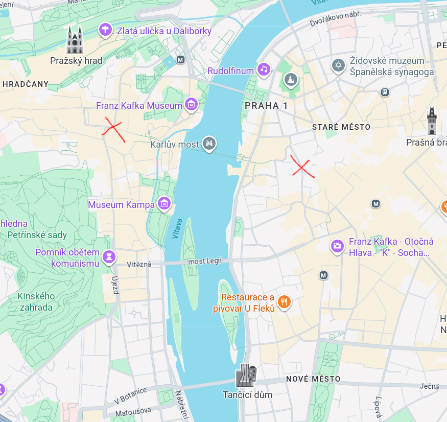
-
 R rivoluzioneurbanamobilita@poliversity.it ha condiviso questa discussione


![]() Citiverse è un progetto che si basa su NodeBB ed è federato! | Categorie federate | Chat | 📱 Installa web app o APK | 🧡 Donazioni | Privacy Policy
Citiverse è un progetto che si basa su NodeBB ed è federato! | Categorie federate | Chat | 📱 Installa web app o APK | 🧡 Donazioni | Privacy Policy